
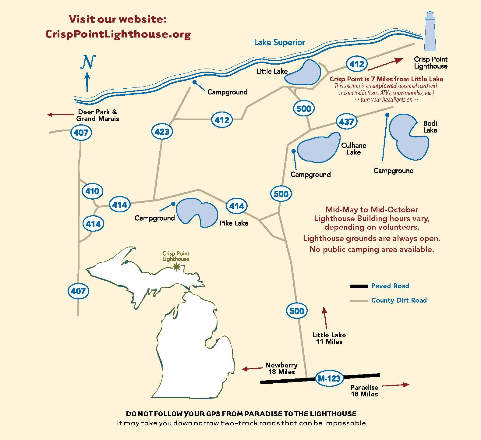
snowmobilers, click here for special trail information! Please remember that the last 7 miles of Luce County Road 412 to Crisp Point is a seasonal road that is not snowplowed in the winter. It also becomes snowmobile Trail 8. Do not drive your car or truck on Trail 8 when there is snow! Also snow accumulations take longer to melt than in the lower Peninsula of Michigan and can make the road impassible even in the spring. Usually it is open by the end of May but make sure it is open before you take this trip.
This is not really a trip, it is more like an adventure. The trip is approximately 37 miles from Newberry, Michigan and takes about 1 hour and 10 minutes driving normally. The road goes through some of the best scenery in this part of the state and you will see some of the most undeveloped land in the Eastern States. At the lighthouse you are about 18 miles from a paved road, 23 miles from the nearest electricity, and 27 miles from the nearest gas station, restaurant, and grocery store. So make sure you have plenty of gas, maybe some snacks, something to drink, film for your camera (unless it's digital!), and plenty of insect repellent as the mosquitoes and flies can get quite bothersome at times. You might even want to bring pants and long-sleeved shirts in case the biting flies are out. Also note that due to sandy areas we do not recommend taking this trip with road motorcycles. Once you get off of M-123, the roads are all dirt or sand, are narrow and curvy in areas. As with any trip you take on public roads, you do so at your own risk. Please use caution and drive slow. Road conditions vary due to the weather and if the county road crews have been out, so we cannot guarantee that you won't get stuck. We also recommend turning your headlights on to help others see you. Watch out for ATVs on the dirt roads!

For those of you with GPS navigation systems, we suggest that you do not rely on them because we have heard that sometimes they take you on roads that only off-road vehicles can get through.
- 00.0 Center of Newberry, Michigan, go north on East M-123.
- 18.5 Turn left onto Luce County Road 500. This is a gravel road. | Photo 6 |
- 24.7 Luce County Road 414 goes off to the left - stay on County Road 500. | Photo 7A | |Photo 7B | | Photo 7C |
- 24.9 You will cross a bridge. | Photo 8 |
- 25.0 County Road 506 branches off to the right - stay on County Road 500. | Photo 9 |
- 25.8 You will come to a sign with an arrow pointing both ways - go right, staying on County Road 500. | Photo 10 |
- 29.1 You will see Culhane Lake on your right. | Photo 11 | | Photo 12 |
- 29.2 Fork in the road - take the left fork and stay on County Road 500. The other (County Road 437) goes to Bodi Lake. | Photo 13 |
- 29.9 County Road 503 comes into road from the right. Go straight and stay on County Road 500.
- 30.0 Road forks - take the right fork. You are now on County Road 412. | Photo 14 |
- 30.2 You will see Little Lake Harbor through the trees on your left.
- 30.4 County Road 412 forks off to the right - go right. This is a seasonal road and is not plowed in the winter. It also becomes Snowmobile Trail 8 when there is snow. Do not drive your car or truck on Trail 8! | Photo 15A | | Photo 15B |
- 33.9 You will come to a large clear cut area in the forest that is recovering quite well. There are a lot of small pines and ferns as far as you can see. | Photo 16 | | Photo 17 |
- 35.0 You will turn left onto a smaller road, which is still County Road 412. There is a County Road 412 sign on the right side of the road with an arrow pointing to the left. | Photo 18 | | Photo 19 |
- 36.9 You will come to the old parking area and you will be able to see Lake Superior. Follow the road and signs to the lighthouse.
- 37.2 Park in the parking lot and walk to the lighthouse via the boardwalk. The address for Crisp Point Lighthouse is 1944 County Road 412, Newberry, MI 49868 and the Visitor Center phone number is 906-658-3600.
NOTE: Although some of the best sunsets in the world are available here, we do not recommend staying after dark as it is very easy to get lost on the winding roads and help is not readily available. If you have a cell phone you should be aware that it will probably not work at the lighthouse.


Email us with comments at info@crisppointlighthouse.org
Copyright © 2022-23 Crisp Point Light Historical Society
Last Modified January 22, 2023